
Places to visit
Birlik (jailoo) KG
Pastures of Toktogul region, situated on the west side of the Kyrk Kyz pass.
Bishkek KG
Bishkek is one of the greenest cities in Central Asia. About 150 different kinds of trees and bushes are planted in the streets of the city. There are many cinemas, Opera House, Kyrgyz and Russian Drama Theater, Mosques and Orthodox churches, historical complex of the national hero - Manas- “The Manas Ailly”, zoological, geological art and other museums, exhibitions of decorative and applied art, colorful oriental bazaars are others interesting places you are invited to visit.
On bazaar one can see really traditional handiwork of Kyrgyz land and goods from all around the world at reasonable prices. There are remarkable parks and shadowy boulevards Erkindik and Molodaya Gvardia, pensioners like to walk there, sportsmen run along its alleys, kids play and young people date here.
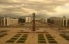
Bishkek - capital, heart of the Kyrgyz Republic, its political, economic, scientific and cultural center, the main transport unit. Bishkek - the location of the supreme bodies of the government of republic, embassies and representations of the foreign states. Bishkek is located in the center of the Chuy valley, at bottom of snow-white mountains of Kyrgyz Ala-Too, at height of 750 m. above sea level.
The area of territory - 160 sq. km, the population - about 1 million person. The city residential areas which have arisen at various times, differ on the planning structure and a degree of an accomplishment. Last years are characterized by occurrence on adjoining to city of territory of some new buildings with the microstructure. The city on administrative-territorial division is broken into 4 areas: Leninsky, Pervomajsky, Sverdlovsky, Oktjabrsky.
In Bishkek the most part of all industry of Kyrghyzstan is located. Feature of planning structure of the city of Bishkek is development of industrial zones along the railway. In city two industrial zones are allocated: east and western. The system of transport and foot ways connects industrial and administrative areas among themselves. Gardening is submitted by squares, parkways, parks, adjoining to city the territory is planted by forest plantations, there are lakes and water pools.
The science and education are submitted by the National academy of sciences and a plenty of average special and higher educational institutions. Bishkek - the center of national culture of Kyrghyzstan. Here there are theatres, a philharmonic society, libraries, museums.
Intensively the information infrastructure of city develops: some Internet providers already work, a plenty of local, global, corporate computer networks is created. Two operators of cellular communication, some operators of a paging and trunk radio communication work.
Black Dragon Pool park CN
Blue Mosque Harzat Ali Shrine AF
The Blue Mosque is the center of all the social and religious life of the city. It would be built on the tomb of Ali ibn Abi Talib, relative and companion of the prophet Mohamed. The Sultan of the Seljuq dynasty, Ahmed Sanjar (1118-1157), built the first known shrine at this location. It was destroyed during the invasion of Genghis Khan around 1220. In the 15th century, Timurid Sultan Husayn Bayqarah Mirza built the current Blue Mosque here. The shrine is surrounding by Rawza parks.
Bodhnath NP
The Boudha or Boudhanath stupa is one of the most important religious monument in Nepal. Located west of Katmandu, in a district mainly inhabited by Tibetans, and it is one of the arrival points for refugees arriving from neighboring China. The atmosphere is unique and it is good to spend time strolling around the temple. It's also one of the best places to browse antique shops.
Bokonbaeva KG
Bokonbaevo is the most important agglomeration on the southern shore of Issyk-Kul. This place is not only famous for its beauty, but it is also a center of eco-tourism. The village is located 160 km from Karakol and 280 km from Bishkek. Tourists come here to experience the nomadic life of the Kyrgyz people, the fresh and pure mountain air and for the splendor of Issyk-Kul lake.
The inhabitants of the village live from agriculture and crafts. Once a year, the “Salburun” festival takes place here. Hunters compete with golden eagles and hawks for small and large game, with bow and dogs. Horse races are organized in particular.
Before the Russians, the village was called Kok-Kytan. In 1912, the Russians gave the name Kolsovka. The village took the name of Bokonbaevo, in 1944, in honor of the Kyrgyz poet Joomart Bokonbaev.
Bolo Hauz mosque UZ
The Bolo Hauz mosque is a mosque in Bukhara, Uzbekistan.It was built in 1712, also it is a World Heritage Site by Unesco.
Boom gorge KG
The main main road connects the Oblast of Chuy and that of Issyk Kul by a canyon 40 km long. But this passage was only opened during the expedition led by explorer Pyotr Semionov-Tian-Chanski in 1857. The colors of the rocks are incredible. You can visit several small canyons with red rocks like the Creek canyon.
Boris Eltsin peak KG
Boris Yeltsin Peak is the 3rd highest peak in the Terskey Alatoo mountain range. It is part of the Oguz-Bashi massif group. The easiest route is from the south, via the Boroko glacier.
Boroko glacier KG
Glacier on the South side of the peak Boris Eltsine and the massif of Oguz-Bashi. It's situated in the National park of Sarychat Ertash.
Buddhist temple in Vrang TJ
Not far from the castle in the village Yamchun Vrang Ishkashim at the point where they exit from the gorge Vrang-Darya, the right tributary of the river Panj, unearthed a large religious complex, which is seen as a Buddhist monastery.
Bugu ene KG
Karakol Zoological Park was founded in 1987. It is the only zoo in Kyrgyzstan. But after the collapse of the Soviet Union, the country's economy was severely eroded and in 2001 the zoo almost closed. Fortunately, partners and sponsors have been able to preserve the wildlife and keep the parks in relatively good condition.
Managed by NABU from 2003 to 2013, it is today managed by the Bugu-Enye Foundation. The aim of this park is not to increase the variety of animals, but to collect wild animals in difficulty.
The Bugu-Ene Foundation is a Kyrgyz non-governmental organization with its charter and its founders. The main subject of activity is the unification of the efforts of all interested parties in the organization of assistance in the implementation of specific actions for the conservation, respect, study and preservation of fauna and flora The activity of the “Bugu-Ene” Foundation is carried out in close cooperation with the Kyrgyz National Agency for the Protection of the Environment and Forests, the State Inspectorate for Ecology and the services veterinarians of the Kyrgyz Republic, as well as with the police.
The main objectives of the Fund:
- Help save injured animals and birds that can no longer survive in the wild.
- Help wild animals caught in extreme situations, as well as protect wild animals and birds from poaching and unauthorized capture.
- Implementation of educational activities: conferences, animation of training seminars, conferences.
- Conduct special events and media campaigns aimed at raising public awareness of the responsible attitude towards animals.
- Guard of the Bugu-Ene zoo in Karakol
The work of the Fund also extends to the preservation of the unique flora of the Republic, the restoration of forests and respect for them, as well as the search for solutions to many other tasks of wildlife preservation .
The collection of the Bugu-Ene zoo includes 34 species of animals and birds, or around 140 individuals. Animal feeding is carried out in accordance with a scientifically based diet, based on the methods developed at the Moscow Zoo.
Why should you visit this zoo?
Nomad's Land encourages its travelers to visit this park because the park entrances are one of the most important revenues for the self-financing of the Foundation. This park is unique in Kyrgyzstan, its closure would be a disaster for the preservation of wildlife in Kyrgyzstan.
The Bugu Enye Public Foundation reminds all those who want to help save wild animals their bank details:
Optima Bank OJSC
BIC 109018
SWIFT: ENEJKG22
Account number 1091820239920161 (multicurrency)
TIN: 02806201310246
OKPO code: 27648901
Social Fund registration number 201-01-02-502
Email: seitova23@mail.ru.
Money can be transferred to Elsom - 0553634238.
Bukhara UZ
Bukhara is the capital of the Bukhara Province of Uzbekistan. Bukhara is a city-museum, with about 140 architectural monuments
Bukhara International Airport UZ
Bukhara International Airport is an airport serving Bukhara, the capital city of the Bukhara Region inUzbekistan.
The best airport of the CIS, in the category of terminals, serving 100 to 500 thousand people.
Currently, aircraft are serviced by a number of Russian airlines operating both passenger and freight.
Bulgan MN
Burana Tower KG
Burana Tower is seven km. far from the city of Tokmok. It is an 11th century minaret, and one of the first buildings of such type in Central Asia. The original height of minaret was 45 meters. Today the tower is 24.6 meters high, the remaining part came down during an earthquake in the 15th century. In the 10th to 12th centuries, Karakhanids khanate was a great feudal state of Central Asia and Kazakhstan.
The founders, "karakhans", chigil tribes by birth, lived in the Tien-Shan and for a short time of the second half of the 10th century they conquered a large territory. One of the capitals of this state was Balasagun. In Karakhanids' time new towns and settlements were developing, the centers of big cities were improved and Moslem religious buildings were built in the town of Balasagun. Burana tower, mausoleums and other buildings found after archeological excavations are the witnesses of that build up. The town's life declined slowly, people left it, the buildings fell apart and finally in the 15th century it ceased to exit.
Caravanserai of Culture UZ
International Caravanserai of culture Ikuo Hirayama in Tashkent is a unique object, which is both a museum and a scientific and cultural center.
CBT Arslanbob KG
Coordination office of CBT Arslanbob leading by Hayat. Our local partner for trekking, horseback riding and ski touring in the region of the largest nuts forest in the world. With Hayat the coordinator of CBT Arslanbob, we are developing new routes and programs. In partnership with the Swiss NGO "Boule de neige", we are supporting winter sport access to children of Arslanbob village.
CBT Chong Kemin KG
Nomad's Land with CBT Chong Kemin offer an amazing trek routes to the Issyk Kul lake. Janybek is the coordinator of the association based in the village of Karol Doeboe
CBT Talas KG
CBT Talas offers a good alternative to poor housing that can be found in the town of Talas. Turdubek, the coordinator, will be glad to show its oblast. CBT Talas as one the most important ecotouristic actor in Talas is our partner in order to organize the long trek between Talas and Sary Shelek lakes. Ask us for our cultural, horseback riding and trekking's programs.
Chaek KG
Chaek is the administrative center of the rayon of Jumgal. Its bazar is now replaced by many small shop on the border of the main street.
Chakhrisabz UZ
Shakhrisabz is a city in Qashqadaryo Province in southern Uzbekistan. It was founded more than 2700 years ago.
Chaldovar border post KG
On the main road from Bishkek to Merke in Kazakhstan.
Join us on Facebook!
And keep updated with our tour promotions, or follow us on
Instagram Twitter YouTube Linkedin